Buying rail tickets for train travel in the UK is complicated. Despite some simplification introduced last year, it’s still possible to buy a range of rail tickets at different prices that will get you on the same seat on the same train.
Buy your rail tickets in advance, and as early as possible – you can get them up to 3 months ahead.
Rail tickets bought on the day (so-called ‘walk on fares’) offer lots of flexibility but are also usually the most expensive – you can book as little as 48 hours in advance and save a lot of money.
You can usually book any ticket from any train company, even if your journey doesn’t use their trains. So you could book with CrossCountry to travel on a First Transpennine Express (FTPE) train and get the same price as you would booking direct with FTPE.
Rail Easy displays fares in a different way which can make it easier to find cheaper tickets. I also found that they are more likely to send tickets by first class post for free, rather than charge £6 for next-day delivery. They do charge a booking fee though.
If you spend more than £76 per year (or £6 per month) on rail tickets, get a railcard. If you are between the ages of 16 and 25 you can get a 16-25 railcard. You can order a new one right up until the day before your 26th birthday too. Family railcards and senior railcards are also available. They give you 34% off the price of almost all train tickets, including those booked in advance.
Sometimes two single rail tickets are cheaper than a return – always check both. This is especially true if you book in advance.
Megatrain is worth a look as its fares start from £1 (plus 50p booking fee). Trains run from Sheffield, Derby and Portsmouth into London, but there are connecting coaches from cities like York and Bradford (I travelled from York to London for a total of £3.50 last year). There’s also additional discounts for NUS Extra card holders.
There are many more tips out there, which shows how confusing the system is. Ultimately, the best way to get the cheapest fare is to book as far in advance as possible, use a railcard and shop around a bit.
In my ‘Bradford – a tale of two stations‘ post a few weeks ago I mentioned that many plans had been made to connect the city’s two stations together over the years but nothing had come of it.
The latest set of plans have been published by a couple of local businessmen. It would create a new station called ‘Bradford Central’ which would be on the bridge carrying the tracks through the city. This would be linked to the existing bus station at Bradford Interchange but it’s probable that the two railway stations would close under the plans.
The proposed station certainly looks good in the artist drawings, and very little demolition would be necessary – just the Royal Mail depot at Forster Court (which has been earmarked for eventual demolition anyway as far as I am aware). It would take some land from the Westfield development but would have the advantage that the site would be very close to the station – therefore increasing footfall in the proposed shops. There’s even a chance that Westfield would help fund it, as they did in London when their White City shopping centre opened recently; this saw a new railway station, new Tube station and another Tube station extensively refurbished with Westfield putting up a lot of the money.
The projected cost of the scheme would be £100m, which is a lot of money. We’ve just come out of a recession and the massive public fund deficit means that money from central government is probably not going to be very forthcoming.
The design of the station would make any potential expansion difficult – it provides 4 platforms but this is less than the 7 that the two existing stations provide between them. Of course, should the platforms at Bradford Interchange remain open for terminating services then potential capacity problems would be alleviated somewhat. However, adding extra platforms to the new station would be very difficult due to its elevated state, and the probably lack of land to expand into.
Despite all this, I really, really hope that this comes to fruition. The current station at Interchange looks very dark and tired, and needs replacing. Enabling through services, rather than having trains reverse, would make routing trains through Bradford more attractive. And it may be the catalyst that gets the Westfield development back on track and would give people more reason to visit the city. But it’s early days and we’ve been in this situation many times before – I’m not getting my hopes up.
One of the things often said about Bradford is this:
Bradford has two train stations – but you have to change at Leeds to go anywhere!
While that’s not strictly true, as Bradford does have regular direct services to York, Manchester, Preston, and, from later this month, London, to go to many places outside the north of England it’s necessary to change at Leeds or Manchester. Bradford may have two stations, but both are quite small and only serve regional trains and commuter services – apart from the aforementioned London service starting in 3 weeks time, there are no inter-city services.
It wasn’t supposed to be this way.
First stations
Bradford’s first station was opened in 1846 by the Leeds and Bradford Railway Company, and was a line from Leeds Wellington Street (now Leeds City station) via the Aire Valley and Shipley. Until then, Bradford’s closest station was Brighouse, which was then known as ‘Brighouse for Bradford’, opened in 1840. The station was located off Kirkgate, to the north of the city centre.
In 1850, the Lancashire and Yorkshire Railway built another station, known as Bradford Exchange, to the south of the city centre off Hall Ings.
In 1853, the rapidly-expanding Midland Railway took over the Leeds and Bradford Railway, and the first Bradford station was re-built.
Yet another station, Bradford Adolphus Street, was added in 1854, by the Leeds, Bradford and Halifax Junction Railway. This station was short-lived; it was the furthest from the city centre and closed to passengers in 1867; services were diverted to Bradford Exchange. It remained as a goods station until the 1960s, when it was closed, and was demolished in the 1980s when the A650 Wakefield Road was widened.
Rebuilding
With Bradford Exchange taking on Bradford Adolphus Street’s passengers as well, it became necessary to expand the station in the 1880s and a new 10-platform station was built on the same site. Operationally the station acted as two separate stations; part for the Lancashire & Yorkshire Railway and the other for the Great Northern Railway, with separate booking offices.
Mirroring the trend, the Midland Railway’s Bradford station was rebuilt in the 1890s with 6 platforms, and this included the building of a goods station and a hotel, which survives today as the Midland Hotel. From around this time, the station was known as ‘Bradford Market Street’ to differentiate it from the Exchange station. Bradford now had 2 large stations, with 16 platforms between the two.
In the 1900s Midland Railway had completed its Midland Main Line between London and Leeds, and the Settle-Carlisle Line between Leeds and Carlisle, however, it didn’t own the tracks to Leeds and trains were required to reverse. It therefore had an ambitious plan for a new line via its Bradford Market Street station, involving a long tunnel through the city. Trains would therefore be able to operate directly from London to Scotland, via Bradford.
Unfortunately, this never happened; the first world war broke out and this caused the end of the age of prosperity for the railways. In 1923, the multitude of small railway companies were forcibly grouped into four large companies; after the second world war became nationalisation and the creation of the British Railways Board. Around 1924 ‘Bradford Market Street’ became ‘Bradford Forster Square’.
Beeching
The Beeching Cuts of the 1960s hit Bradford quite hard. Many local services were cut, and the Wharfedale Line to Ilkley was proposed for closure. Thankfully, it was saved through local council subsidies. The cuts meant that by 1973 Bradford Exchange was too big; there were not enough services to justify having 10 platforms. A new station was built further away from the city centre, near Bridge Street, with just 4 platforms; this is the station which survives today. In 1983, a bus station was opened next to the railway station and it was renamed ‘Bradford Interchange’ to reflect its status as a multi-modal transport interchange.
In the early 1990s, Metro, West Yorkshire’s public transport executive, decided to fund the electrification of the Airedale and Wharfedale lines to promote passenger growth. In doing so, it was decided to close the existing station at Forster Square, which was also now too big for the small number of services still running and had become very run-down, and construct a new station taking over the ends of the platforms on the city centre side of the station.
Present day
Which brings us to the present day. Unlike 100 years ago, when Bradford had two large stations and direct trains all over the country, we now have two small stations with 3 and 4 platforms respectively. Had the Midland Railway’s grand plans gone ahead, Bradford would have been a key destination on the Midland Main Line, instead of Leeds. I have no doubt that the history of the twin Yorkshire cities would have been very different had that line been built.
But why does Bradford still have 2 stations? In other cities like Leeds, Sheffield and Birmingham, rationalisation in the 1960s saw smaller stations closed and routes combined to create large central stations. If you look at a map of Bradford, you’ll even see that the two stations roughly align with each other. Furthermore, there’s presently not a lot of buildings in between them, due to most of the land having been cleared for the mothballed Westfield shopping centre. Couldn’t they be connected up?
The plan has been mooted many times over the years, however, it’s not that simple. First of all, although the stations are on the same alignment, there is a considerable altitude difference; Bradford Interchange is several metres higher up than Bradford Forster Square which is at the very bottom of Bradforddale (the valley that links Bradford with the Aire Valley). Any railway line would have to be carried by bridge across the town, and with quite steep gradients. As well as Westfield, there are other building such as the new Magistrate’s Court which are planned for the land where the tracks would go. And despite being talked about for years, nobody has come up with any detailed designs, nor the money for such a line. And in any case, Bradford is not a strategic place on the railway network – all of the lines that serve it are purely regional or for local commuters. If it was to be built, it would cost a lot of money which probably wouldn’t provide much benefit, considering that Bradford is well away from the main lines. Its proximity to Leeds doesn’t help, either.
While train services to Bradford have improved somewhat over the past 20 years, I don’t expect to see any big plans for Bradford like we saw 100 years ago. I guess we’ll still be changing at Leeds for years to come.
This is an entry about the Calder Valley Line (also known as the Caldervale Line), which takes trains from my home town of York, through to Bradford where I currently reside, and onto Manchester and Blackpool, where Christine lives. As you can imagine, I use this railway line a lot.
Technically speaking it’s a ‘route’ rather than a ‘line’, as the sections of track were built at different times by different companies and it shares tracks with other services for a number of sections, but it’s known as the Calder Valley Line. This is because it passes through the upper Calder Valley.
Bradford and Blackpool are on roughly the same latitude, so in an ideal world there would be almost a straight line between them. Alas, the Pennine Hills are in the way, and so the railways tend to follow the valleys and serve the communities in them. Indeed, on leaving Bradford the trains head almost due south, before then curving around to face south-west to reach Halifax.
The line certainly isn’t the most modern in the country. It saw quite a bit of attention in the 1980s, when a number of stations closed in the 1960s were re-opened, and new trains were introduced for some services in the early 1990s. But apart from a new junction outside Bradford there hasn’t been much significant investment in the line of late. Some sections, such as the 9 miles between Burnley and Todmorden, have very slow line speeds of around 45 mph, compared with the usual minimum of 60 mph elsewhere. Consequently, the train from Bradford to Blackpool takes 1 hour and 50 minutes, which is slower than it would be to drive (around 1 hour 35 minutes) despite the driving route taking you via Manchester and being much further in distance.
But some changes are afoot. South of Bradford, a new railway station at Low Moor should be open by the end of 2012, again to replace one closed in the 1960s. Blackpool trains, which skip many intermediate stops elsewhere, won’t stop there but it will be served by a number of local services, and its location close to the M606 on the site previously occupied by Transperience means it will be suited for park-and-ride facilities. Manchester Victoria station is due for a major refurbishment and by 2017 there should be more frequent services to Bradford, as well as new direct services to Manchester Airport and Liverpool from Bradford. A new section of track will allow trains from Burnley to reach Manchester via Todmorden, although this plan is presently unfunded, And the line connecting Blackpool to Preston is due to be electrified later this decade, although that will largely benefit local services and not trains from Yorkshire.
A faster service to Blackpool from Bradford would be most welcome – obviously it would be nice for me but if it becomes faster than travelling by car then it will be more likely to pull in extra passengers. New or refurbished trains would be nice; while the Express Sprinter trains that usually run on the line aren’t too bad, they’re in need of a refit as many carry most of their original fixtures and fittings which have become well-worn over the past 20 years.
The Calder Valley Line is a useful route, covering a long distance and linking many northern towns together, but it could really do with some more TLC. Hopefully in 10 years time I won’t have to use it so much, but I can hope that if I do it’ll be a quicker and more comfortable experience.
At the weekend I wrote a new Wikipedia article about Transperience.
The Transperience Museum
Transperience was a museum that I was aware of when I was younger, and I remember seeing leaflets about it. But neither I, nor my parents, had never had the chance to visit it during the short time that it was open.
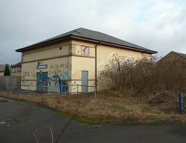
It was essentially an open-air museum of passenger transport. There were some transport simulators, as well as a working one kilometre tram line and a couple of trolleybuses. In addition, there was an auditorium and some workshops were its preserved vehicles were maintained.
The museum was built on the site of Low Moor station, south of Bradford. The station used to be at the junction of the Caldervale Line, between Bradford and Manchester, with the Spen Valley Line which ran through Cleckheaton, Heckmondwike and Liversedge. The station, and the whole Spen Valley Line, were closed in the 1960s, but the Caldervale Line thankfully remains. Otherwise, my regular trips to Blackpool would be far more difficult.
Closure
Despite being right next to junction 2 of the M606 and easy reach of the M62, and costing £11.5 million to build, the park closed in 1997. It had only been open for a little over 2 years. Unfortunately, it couldn’t attract enough visitors to be viable, and was £1 million in the red by the time it was taken over by administrators. The land was mostly sold off to a private developer and is now an industrial estate. The route of the tram line now forms the first part of the Spen Valley Greenway, a footpath and cycle route which follows the route of the Spen Valley Line. Some buildings, like the auditorium remain, but overgrown and derelict.
Interestingly, the site is likely to go full circle. Metro, the public body which manages passenger transport in West Yorkshire, has plans to re-open Low Moor station. Its location close to the M606 means it would make a good parkway station. Plus, it will allow residents of Low Moor and towns in the Spen Valley to catch the train without having to travel into central Bradford or Leeds. It’s likely that the few remaining relics of Transperience will be tarmacked over by the new station’s car park. The station is proposed for 2012, subject to planning permission and funding.
It’s a shame that I never had chance to visit Transperience, as it seemed like an interesting museum that suffered from poor marketing and a lack of focus. Thankfully, museums such as the Crich Tramway Village have succeeded where Transperience failed.
Update (Dec 2016): Work on the new Low Moor railway station is underway, with a likely opening date in 2017. Most of the Transperience infrastructure that remained by 2010 is still there, albeit still abandoned.
This is a screenshot of the National Rail Enquiries website, specifically the ‘transport links’ section of the information page for Denton station in South Manchester. If you can’t read the screenshot, or if the page gets changed, it says the following:
Location for Rail Replacement Services: Outside the Rovers Return on Coronation Street
For those who are not familiar with British TV shows, the Rovers Return Inn is a fictional pub in the soap Coronation Street. Though the soap is set and filmed in Manchester, there is no such street anywhere near Denton station.
It’s therefore likely that someone at National Rail Enquiries, or whoever supplies the data, had a little joke, because it’s highly unlikely Denton will ever have replacement bus services (or at least, not in the near future). Denton station is currently only served by one train per week, currently running during the daytime on Fridays, on a service between Stalybridge and Stockport. The station itself has just one platform, and there aren’t even any signs there – just a bench and some lights.
It was never always like this. Back in the early 1990s, the Stockport to Stalybridge line saw a regular service. This was because trans-pennine trains from Leeds would call at Manchester Victoria, which only serves other local and regional services. Mainline services to London and Scotland instead departed from the bigger Manchester Piccadilly, and so this service allowed those wanting to travel from Leeds to destinations south of Manchester to bypass the city and connect with mainline services at Stockport.
But the trans-pennine trains were diverted to Manchester Piccadilly in the 1990s and Metrolink started operating in 1992, and so this service was seen as largely unnecessary. But because the trains on this route were the only ones that called at Denton, and Reddish South further along the line, the decision was taken to keep a minimum service running to avoid the legal processes of formally closing the stations. Thus, the service that now runs is a ‘Parliamentary train‘, to maintain the ‘legal fiction‘ that the station is open when in fact it is all-but closed.
There are at least 10 stations in the UK which are served by one service per week to keep them open. Some others have been closed ‘temporarily’, which means that no trains need call there but a designated rail replacement bus operates. A recent example was the Watford and Rickmansworth railway in North London – closed in 1996 but it was still possible to buy train tickets to it nearly 10 years later. Thankfully, that line may have a future as the proposed Croxley Rail Link.
Now I live in Bradford, and this surprises me. To start with, here’s what is good about transport in Bradford:
Roads – Bradford has good links with the M62, via the M606 and the A650/A641, and the bits of the central ring road that have been completed make for a good bypass of the city centre. The signposting is generally good and even at peak times traffic generally keeps moving.
Buses – Bradford Interchange is a large, modern bus station with both short and mid-distance bus services and long distance coach services serving a wide variety of destinations, including many airports. It’s also connected to the railway station. Bus services are frequent and reasonably cheap.
Trains – Bradford has two railway stations, with trains at least every 15 minutes to Leeds all day and regular local services. A couple of trains run direct to London each day.
But there’s a lot that needs improving.
Roads
The central ring road isn’t finished, and probably never will be. Part of the missing bit requires demolishing listed buildings around the university, or tunnelling underneath it, which would be prohibitively expensive. The missing section therefore uses older roads in the city centre, which makes for a confusing one-way system on roads not designed for the level of traffic they now take.
And while the road connections to the south and to Leeds are adequate, to the north the road quality falls sharply. Anyone who’s ever wanted to drive from Bradford to north Lancashire would testify to this, as you crawl through places like Saltaire and Keighley. Leeds Bradford Airport, for example, is only accessible via a single carriageway A-road, which passes through suburbs and villages on the way. And the outer ring road is mostly a joke – it’s a series of existing roads roughly forming a ring around the city that were designated a number. Most sections are not designed for the amount of traffic they now carry, and so it’s often quicker to use the central ring road rather than try to avoid the city altogether.
Buses
To be honest I don’t have a lot to fault Bradford’s bus services on – compared to other cities they’re pretty good.
Trains
One of the local sayings here is on the lines of ‘Bradford may have 2 railway stations, but you still need to change at Leeds to go anywhere’. Unfortunately this is quite true – the direct service to London is only twice a day, and there are no long distance services, just hourly mid-distance trains which stretch out to York, Manchester, Wakefield, Blackpool and Preston.
To go anywhere else, and you have to change at Leeds or Manchester, and since the trains call at Manchester Victoria and not Piccadilly, you might as well just go via Leeds. Leeds Bradford Airport is one of the few airports in the country that doesn’t have a railway station or concrete plans for one, despite its proximity to the Leeds-Harrogate railway line. Most of the trains which run into Bradford Interchange are at least 15 years old and tend to be handed down from other companies when they get new trains – the only ‘new’ trains running into Bradford are those which serve Ilkley, Skipton and Leeds from Bradford Forster Square.
Bradford’s transport links aren’t bad on the whole, but to call them the best is laughable. There is so much that can be done to improve transport here, especially the railways.
Four more days in the life of me while on holiday. I’ll write more as I have time, but at least now the first week is done.
Monday 30th June
Le Grau du Roi
The plan for today was to visit Aigues-Mortes in the Carmague (about an hour and a half driving from where we were staying) and then have a look at le Grande Motte which was just down the road. But on the way we passed this coastal town called Le Grau du Roi, and thought we’d take a look.
It’s not particularly big and isn’t exactly a world heritage site, but it does have an old lighthouse and is full of seafood restaurants – as you’d expect for a major fishing port. There’s a few old buildings, and a swing bridge in the centre of the town over the canal. If anything, it’s a bit like Sète, albeit less posh.
Aigues-Mortes
We probably spent about an hour there before heading on to Aigues-Mortes itself. We’d been here 12 years ago (when I was a mere 7 years old), and indeed, I have a near identical photo to the one shown that I took way back then in one of my older holiday photo albums.
Since we spent quite a bit of time in Le Grau du Roi, by the time we’d got here it was heading towards lunchtime, so most of the shops were closing for lunch. Down here, it gets very hot in the early afternoon sun, so most shops close at around 1pm and remain shut until 4pm, though typically they are open later into the evening than in Britain, where everything shuts at 5pm.
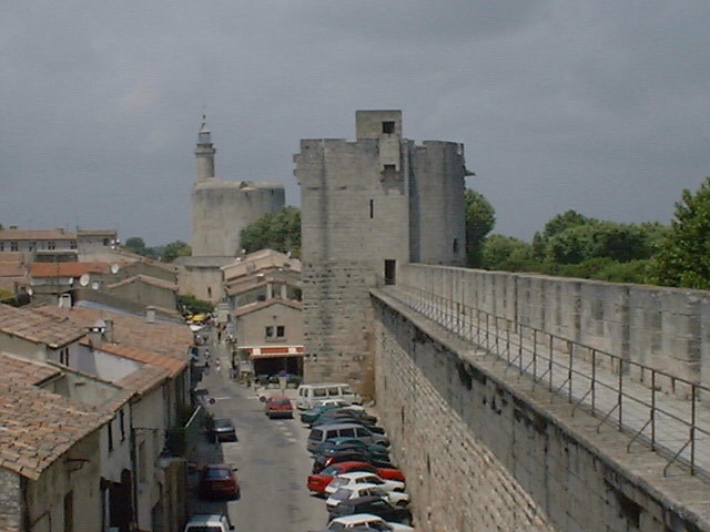
Fortunately, the ramparts, which stretch around the entire old town, were open all day, so we could pass the time strolling along these. They give great views of the town and the surrounding area, which is largely flat since it’s in the delta of the Rhône river. The big white piles are of salt – the seawater is pumped into salt pans and drained, and the area is one of the largest sea salt producers in Europe, apparently. Camargue rice, which is my favourite type, also originates from this area.
So, back to the ramparts (walls, if you must). When we last visited, they were free, but large areas were closed off so you couldn’t walk on them. Now, although you have to pay to get onto them, they form a complete circuit around the town, spanning for 1.63 metres, which is only a few metres longer than a mile. Lifts and ramps have also been added in some parts to allow disabled access – something that I couldn’t see happening in York, although admittedly the way the walls were constructed means that one section is accessible to those in wheelchairs.
After wandering around the walls and climbing up the towers, we strolled along the largely empty streets (the only places that were open were the bars and restaurants) before returning to the car and having lunch. Fortunately, the large amount of flat land around the edge of the town means there is plenty of room for car parks.
le Grande-Motte
Our intention was to visit this town, which is very much like Cap d’Agde in that it’s a seaside resort that was built in the 60s. Apparently a lot of thought was put into the design of the town, so that it didn’t end up like some of the Spanish Costas. Except that one thing they didn’t plan very well was signs for car parking.
We headed for the town centre, to find no spaces. And, as we headed out, the signs weren’t very well positioned, and we ended up going into a suburb of the town, effectively getting lost. And after it took 15 minutes to get back on the right road, we gave up. Of course, as we left the town we spotted a huge sign saying where all the car parks were, but of course it looked completely different to all of the other signs so we didn’t notice it.
Still, the town was twinned with Hornsea, a coastal town in East Yorkshire that I used to visit often with my grandparents when I was younger.
Pézenas
Since it was mid-afternoon when we gave up on le Grande-Motte, we quickly raided the guide book for other places to visit. Pézenas came up – after all, it was only a slight detour from the route home, and it was recommended, so we gave it a try.
Most of the buildings date from the 17th century, and there’s a nice church there, along with a few pretty squares. My parents were more interested in the architecture, dragging me around various old buildings that had the odd carving on them. Not really my kind of thing, but they seemed to find it interesting.
Tuesday 1st July
Agde
Now would be a good time to explain about the Commne of Agde. The Commune consists of four localities: Agde (also known as La Cité d’Agde), Le Cap d’Agde, Le Grau d’Agde and La Tammarisière. They’re basically four towns/villages located near each other, run by the same council, which is good because the tourist office can encourage those visiting the Cap into visiting the other places.
Agde itself is considerably older than the Cap. Whereas the latter was built in the 60s, the main town has been around for over 2500 years, making it older than many places in the UK (even York is only 1932 years old, founded in AD71). That said, much of the town is considerably newer.
Most of the buildings are made out of local stone, which is basalt. The nearby Mont St-Loup, which overshadows the commune, is an extinct volcano, so the rock is all volcanic, hence the dark colour of most buildings. In fact, the cathedral looks like it’s been made out of glorified breeze-blocks, although it did have some nice stained glass windows to make up for it.
Like Sète, Agde has jousting competitions, and in fact during the time we were there the local jousting association was celebrating its 100th anniversary. The boats they used were out on the River H�rault, which is where the area gets its name.
Le Grau d’Agde
Another Grau, just down the road from Agde itself (‘grau’ indecently means the mouth of a river, or something like that). It’s similar to Le Grau du Roi in that it is also a fishing village, although it has more of a tourist trade. We hit the town during the market just before lunchtime, which was a mistake because seeing all the food out made me very hungry indeed. The town is also home to a number of very nice restaurants, with seating built out over the river.
To the other side of the river is La Tamarissière, a smaller village that is also part of the commune and linked by a ferry (the nearest bridge is further inland). It’s quite pretty but we didn’t get around to visiting it.
Wednesday 2nd July
Carcassonne
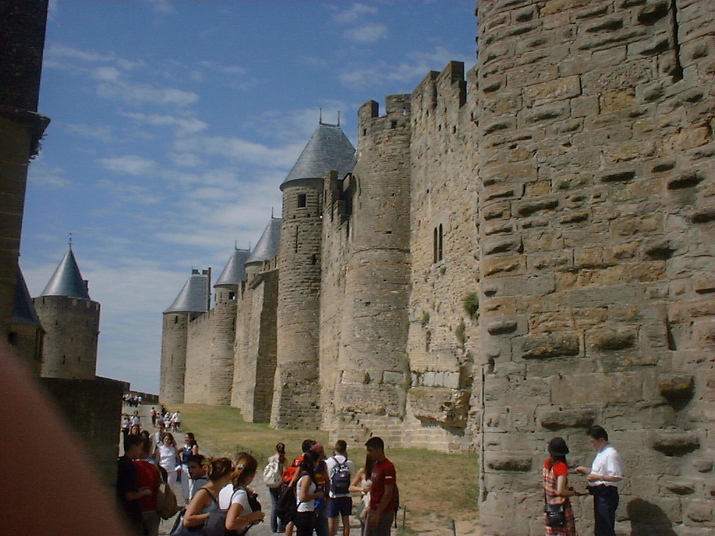
Last time I went to Carcassonne was in 1996, at the age of 12, so I still remember this place quite well. Like Aigues-Mortes, it is a walled city, although Carcassonne is much older. It is up on a hill-top, and very well preserved (dating back to Medieval times), and is a tourist magnet.
So, as you’d expect, even outside full season it was quite busy, not helped by the fact that the streets were very narrow and twisted. It was also full of shops selling tacky souvenirs like plastic swords, but also had many restaurants, which were actually surprisingly cheap. But then that’s probably the result of competition.
There is a castle in the very centre but there was a queue to get in, and I seem to remember we went there last time anyway, so we gave it a miss. Still, it was very nice to visit the place again. I’d love to show you more photos but I’m a little lacking on disk space.
Thursday 3rd July
Today we visited the thing that gave Le Cap d’Agde its name – The Cap. It’s outcrop of hard volcanic rock that stretches out into the sea, and the town has since been built around it. The town’s war memorial is built here, for example. Not hugely interesting but it did give us a chance to explore this end of the town.
This is the first of several posts about what I did on my holidays, initially covering the first four days, with photos. Future posts will have the rest of write-up.
Thursday 26th June
Reims
Reims (pronounced ‘remm’ but most English people say ‘reams’) was the first of our two overnight stops on the way down to the south coast. Having overestimated the delays on the roads (despite heavy traffic on the M11 and A14), we turned up at the motel at 4pm, giving us a whole 3 hours before dinner was served at the restaurant. Instead of vegetating in the hotel room, we went into the centre of the city, since it’s been a while since we last visited, apparently (I have no recollection of ever visiting it, but there you go).
Reims is regarded as being the capital of the Champagne region of France, home to that expensive fizzy alcoholic drink of the same name, so obviously there were a few champagne shops around. However the prices were about the same as we’d pay in England (and probably more than the Calais hypermarkets and wine warehouses would charge) so we passed on the opportunity to stock up. The city itself is nice, with many of the streets in the centre having been pedestrianised partially or entirely, so you don’t spend the whole time dodging traffic. The main square is quite pretty, and includes a fountain and a statue, along with shops and bars, most of which had tables out on the street as is customary in France (and increasingly over here too). It’s here that we stopped for a biere pression (beer from the tap) to recharge our batteries.
Reims is also home to a cathedral and various large department stores, which I had a brief dabble in, however I didn’t buy anything.
Friday 27th June
Touron and Tain l’Hermitage
Having left the motel in Reims, we headed down the motorways towards Valence, calling off at the amusingly named le Poulet de Bresse service area on the way – literally translated it means ‘the chicken of Bresse’ and this fact was reinforced by a large steel sculpture of a hen overlooking the picnic area. Bresse, by the way, referred to the nearby town of Bourg-en-Bresse.
After lunch, we pulled off the motorway (having sneakily avoided Lyon on a new motorway that had only been open 6 days), we arrived at Tain l’Hermitage and its sister twon Touron. These two towns are located either side of the river Rhône, one of the widest in Europe and one of only a few to end in a delta. Tain l’Hermitage is the smaller of the two, and is home to the Crozes Hermitage wine variety. Stocking up with 6 bottles of the stuff from the Cave Cooperative is the main reason for stopping here, but Touron is a nice town to spend a short amount of time in. There is a wooden footbridge linking the two towns, and Touron has a castle and a few older timber framed buildings. Again, we made use of the bar facilities, before heading south to Valence for our second overnight stop.
Saturday 28th June
Sète
We ended up at Sète after visiting probably the largest hypermarket I’ve ever seen in Avignon. We didn’t intend to go to Sète today but we got fed up of the slow-moving traffic on the motorway around Montpellier and pulled off onto the older coast road, which happens to pass through the town.
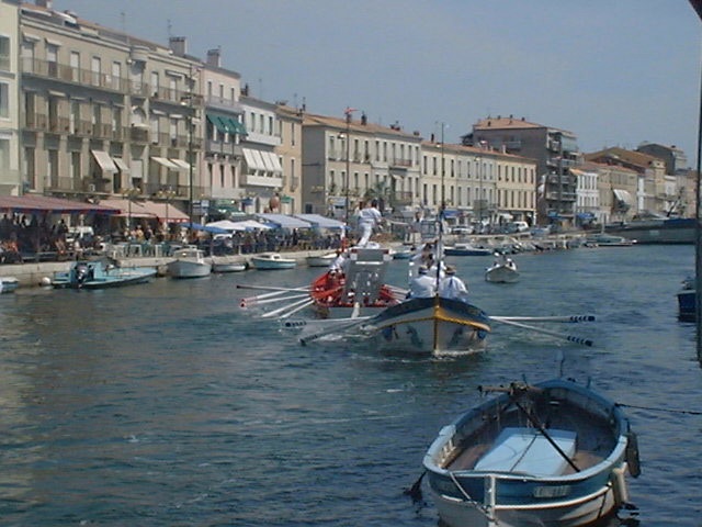
Sète can be best described as the French equivalent of Scarborough, a rather jolly British seaside town just up the road from my home town of York. Except Sète has nicer weather and a canal running through it, and it has water jousting.
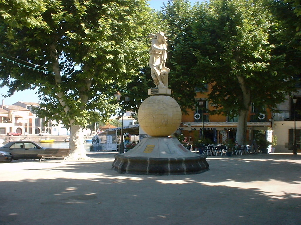
Now, anyone who has seen films about Camelot, or has been to the British theme park with the same name (I haven’t), will know that jousting is usually two knights in armour on horseback with long poles and shields, and the aim is to ‘poke’ the other knight off his horse as the two approach each other. Now apply the same principle, but remove the armour, change the horse into a boat and slow the whole process down somewhat, and you have water jousting. And being a Saturday afternoon during the early part of the tourist season, the locals were out doing it. It’s quite fun to watch, particularly when one of the jousters falls off in a ridiculous way, or, as sometimes happens, they both lose. The activity is obviously part of the town’s heritage as there’s even a prominent statue up in the middle of the town heralding the sport.
While this occupied most of our time here, we did have a brief wander around the rest of the town, which is mostly home to posh holiday flats and seafood restaurants. And some very large seaward pleasure boats.
Cap d’Agde
And, finally, we had arrived. It took us some time to actually find the apartment block that we were booked into as, in the typical French tradition, the signs for it disappeared just as we started to get close. Well, okay, they didn’t disappear but were positioned such that you only saw them once you’d turned to go in the wrong direction. But, anyway, we arrived.
The ‘residence’, as it is known, was called Les Rivages de Rochelongue (Rochelongue being the ‘suburb’ of Cap d’Agde that we were staying in), and to be honest, we’d have been hard-pressed to find a better place. The photo I’ve included here is the actual view from our balcony, which is certainly a par with the view we got when we were in Barbados three years ago. As you can tell, the beach is within staggering distance and the pool is even closer. There’s also a good variety of shops, bars and restaurants literally next door in the Mail de Rochelongue, which is the main street in the area. It also has a most superb ice cream stall, with something like 90 different flavours on offer, including a very nice lavender flavour which I’d never seen anywhere before.
Sunday 29th June
Not wishing to exert ourselves too much after such a long drive down, we spent the morning exploring the town and the afternoon slouched out on the beach.
This will probably be my last entry before I go away on my holidays. Just about everything is packed up now (and in fact it all fits in the car remarkably well), so we’re all set for an early start tomorrow morning. We’re due to leave here at about 4:30am so that we can be in Folkestone for a 11am crossing through the Channel Tunnel. The AA reckons it’ll take us 4 hours and 23 minutes, but bearing in mind we’ll be travelling through rush hour, and will probably need to stop off for breakfast (usually at Bishop’s Stortford on the M11), we’re leaving some extra time. Admittedly we’ll hit rush hour while travelling on some rural stretches of the A1, but still, there’s the M25 and the Dartford Crossing to negotiate. Glad it’s not me that’s driving, but then I can’t drive, so that really is a good thing 🙂 .
Andy will hopefully pop in occasionally to review and publish any comments you guys leave. All that’s left to say is: see you in 2 weeks!


